Research Support System - List of Manufacturers, Suppliers, Companies and Products | IPROS

Research Support System Product List

1~4 item / All 4 items

Displayed results

Rockfall Investigation Support System "Raku Bay"

Streamlining rockfall survey work! The compilation will be completed with ease.

"RakuBay" is a rockfall survey support system aimed at improving the efficiency of rockfall survey operations. It supports the input of survey forms (field work) on-site and the compilation of survey results (office work). The office work consists of an "office system" on Windows computers and a "field system" iPhone app used for inputting and confirming information while in the field. It allows for centralized management of rockfall locations, photo capture locations, rockfall specifications, etc., and through a system structure aligned with business processes, it enables more efficient execution of operations. [Features] ■ Centralized management of rockfall locations, photo capture locations, rockfall specifications, etc. ■ System structure aligned with business processes ■ Enables more efficient execution of operations *For more details, please refer to the PDF materials or feel free to contact us.

  • Other analytical equipment
  • Analysis and prediction system
  • Research Support System

Added to bookmarks

Bookmarks list

Bookmark has been removed

Bookmarks list

You can't add any more bookmarks

By registering as a member, you can increase the number of bookmarks you can save and organize them with labels.

Free membership registration

Land Survey Support System "LandStation-S"

Cadastral survey administrative support system. Supports the report creation part of the E.H process.

This system is a cadastral survey support system that operates on Microsoft Access. It supports the creation of forms for the E and H processes of cadastral survey work. Additionally, it integrates data with the cadastral survey and management system "LandMap-Evoluto," improving work efficiency. Main Features: - Basic pre-survey data input can be done not only by entering each parcel individually but also by importing various types of data. - Command integration with LandMap-Evoluto allows for easy operations such as registering neighboring properties and setting meeting dates. - Data after the cadastral survey can be registered in the dedicated system for F and G process cadastral surveying, "LandMap-Evoluto." - Numeric data after measurement can be imported from the cadastral format 2000, including area and cadastral map numbers.

  • Measurement and analysis equipment leasing and rental
  • Surveying
  • Research Support System

Added to bookmarks

Bookmarks list

Bookmark has been removed

Bookmarks list

You can't add any more bookmarks

By registering as a member, you can increase the number of bookmarks you can save and organize them with labels.

Free membership registration

Land Use Survey Support System "LandStation-Y"

Land survey support system operating on Access. All reports are output in Excel. Compatible with formats from the six prefectures of Tohoku.

- Data is managed in MS Access, and reports are created in MS Excel format, allowing for free editing and delivery. - Inheritance relationship diagrams can also be output using AutoShape, making rearrangement easy. - Registration information is entered while referring to the summary document. You can import registration information in bulk using "Excel input." - By inputting the inheritance relationships from the family register, the heir relationship diagram is automatically created, allowing for editing such as moving items. - Area input can be imported in SIMA or CSV format from various surveying systems, reducing the need for manual input checks.

  • Measurement and analysis equipment leasing and rental
  • Surveying
  • Research Support System

Added to bookmarks

Bookmarks list

Bookmark has been removed

Bookmarks list

You can't add any more bookmarks

By registering as a member, you can increase the number of bookmarks you can save and organize them with labels.

Free membership registration

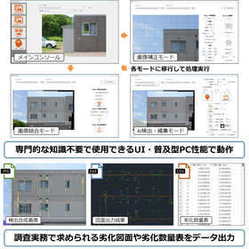
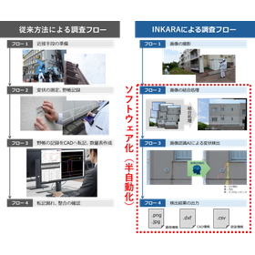
Coating Finish Exterior Wall Visual Inspection Support System INKARA

Automatic detection of exterior wall abnormalities, free trial version of "INKARA" available now!

This is software that automatically detects deterioration such as cracks in exterior walls using AI, supporting inspection work. INKARA is a support system aimed at reducing the burden on technicians by automatically detecting areas of deformation, such as cracks and exposed rebar, from photos taken of the painted exterior walls of buildings. It is designed for technicians to verify and appropriately correct the results automatically detected by AI. 【Software Operating Environment】 OS: Windows 11 CPU: Intel Core i5 or higher Memory: 16GB or more (32GB or more recommended) Storage: 128GB or more (SSD, 512GB or more recommended) *Internet connection is not required. Contact for inquiries about INKARA: support-desk@cons-hd.co.jp

  • INKARAの操作画面と出力結果の例.png
  • 目視調査のフローの比較.png
  • Other Software
  • Structural Survey
  • maintenance
  • Research Support System

Added to bookmarks

Bookmarks list

Bookmark has been removed

Bookmarks list

You can't add any more bookmarks

By registering as a member, you can increase the number of bookmarks you can save and organize them with labels.

Free membership registration